Importing Data
AugmentCity supports two ways to add data to a project:
- Upload a file — import data you have stored locally
- Connect an external source — stream live data from a server
Both options are available in the Layers panel.

File upload
Click + Add layer to open the Import Layer dialog and upload data from your device. The file is stored in the project and loaded into the 3D viewer.
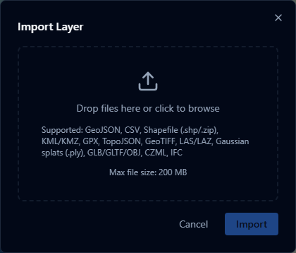
Supported formats:
| Format | Extension(s) | What it produces |
|---|---|---|
| GeoJSON | .geojson | Vector layer |
| GPX | .gpx | Vector layer (converted to GeoJSON) |
| TopoJSON | .topojson | Vector layer (converted to GeoJSON) |
| CSV / TSV | .csv | Point layer (coordinate or address columns auto-detected; all other columns become attributes) |
| Shapefile | .shp, .zip | Vector layer (converted to GeoJSON) |
| KML / KMZ | .kml, .kmz | Vector layer |
| CZML | .czml | Time-dynamic layer |
| IFC | .ifc | 3D building model (converted to GLB) |
| 3D Model | .glb, .gltf | 3D model layer |
| Point Cloud | .las, .laz | Point cloud layer |
| Gaussian Splat | .ply | 3D Gaussian splat layer (converted to 3D Tiles) |
| GeoTIFF | .tif, .tiff | Raster imagery layer (RGB/RGBA) or terrain layer (elevation) |
File size limit: 200 MB per file.
External sources
Click Add URL to open the Add External Layer dialog and link a live data source. No file is stored — the data is fetched from the server each time the layer is loaded.
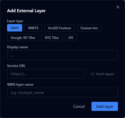
Supported sources:
| Source | Description |
|---|---|
| WMS | OGC Web Map Service — raster imagery tiles |
| WMTS | OGC Web Map Tile Service — pre-tiled raster imagery |
| ArcGIS Feature Server | Esri ArcGIS REST API vector features |
| XYZ Tiles | Slippy map tile URLs (e.g. OpenStreetMap) |
| Cesium Ion | Cesium Ion 3D assets (tilesets, terrain, imagery) |
| Google 3D Tiles | Google Photorealistic 3D Tiles via the Maps Tiles API |
| I3S Scene Layer | OGC I3S / ArcGIS Scene Service 3D scene layers |